Aiguilles Rouges d'Arolla
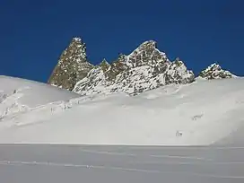
The Aiguilles Rouges d'Arolla are a multi-summited mountain of the Swiss Pennine Alps, located west of Arolla in the canton of Valais. The main summit has an elevation of 3,646 metres above sea level.
| Aiguilles Rouges d'Arolla | |
|---|---|
 | |
| Highest point | |
| Elevation | 3,646 m (11,962 ft) |
| Prominence | 791 m (2,595 ft)[1] |
| Parent peak | Monte Rosa |
| Listing | Alpine mountains above 3000 m |
| Coordinates | 46°03′19″N 7°26′02″E |
| Geography | |
 Aiguilles Rouges d'Arolla Location in Switzerland | |
| Location | Valais, Switzerland |
| Parent range | Pennine Alps |
| Climbing | |
| First ascent | 23 June 1870, by Joseph Gillioz and J.H. Isler |
See also
References
- Retrieved from the Swisstopo topographic maps. The key col is the Pas de Chèvres (2,855 m).
This article is issued from Wikipedia. The text is licensed under Creative Commons - Attribution - Sharealike. Additional terms may apply for the media files.