Alabama State Route 173
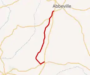
State Route 173 (SR 173) is a 14.462-mile (23.274 km) state highway that serves as a north-south connection between Headland and Abbeville in Henry County. SR 173 intersects US 431 at its southern terminus and SR 27 at its northern terminus.
 | ||||
|---|---|---|---|---|
 | ||||
| Route information | ||||
| Maintained by ALDOT | ||||
| Length | 14.462 mi[1] (23.274 km) | |||
| Major junctions | ||||
| South end | ||||
| North end | ||||
| Location | ||||
| Country | United States | |||
| State | Alabama | |||
| Counties | Henry | |||
| Highway system | ||||
| ||||
| ||||
Route description
SR 173 begins at its intersection with US 431 in Headland.[2] From this point, SR 173 travels briefly towards the southwest before turning to the north as it leaves the town.[2] From Headland, SR 173 follows a northerly track through its northern terminus at SR 27.[3]
Major intersections
The entire route is in Henry County.
| Location | mi[1] | km | Destinations | Notes |
|---|---|---|---|---|
| Headland | 0.0 | 0.0 | Southern terminus | |
| | 14.462 | 23.274 | Northern terminus | |
| 1.000 mi = 1.609 km; 1.000 km = 0.621 mi | ||||
References
- Milepost Map of Henry County (PDF) (Map). Cartography by ALDOT Bureau of Transportation Planning, Survey & Mapping Division. Alabama Department of Transportation. 1999. Archived from the original (PDF) on 2008-06-25.
- Google (May 2, 2010). "SR-173 in Headland" (Map). Google Maps. Google. Retrieved May 2, 2010.
- Google (May 2, 2010). "SR-173 northern terminus" (Map). Google Maps. Google. Retrieved May 2, 2010.
This article is issued from Wikipedia. The text is licensed under Creative Commons - Attribution - Sharealike. Additional terms may apply for the media files.