Brockonbridge Gut
Brockonbridge Gut is a 4.67 mi (7.52 km) long 2nd order tributary to Delaware Bay in Kent County, Delaware. Brockonbridge Gut is the only stream of this name in the United States.
| Brockonbridge Gut Tributary to Delaware Bay | |
|---|---|
 Location of Brockonbridge Gut mouth  Brockonbridge Gut (the United States) | |
| Location | |
| Country | United States |
| State | Delaware |
| County | Kent |
| Physical characteristics | |
| Source | Murderkill River divide |
| • location | Thompsonville, Delaware |
| • coordinates | 38°59′47″N 075°23′54″W[1] |
| • elevation | 9 ft (2.7 m)[2] |
| Mouth | Delaware Bay |
• location | Sandy Point, Delaware |
• coordinates | 39°02′20″N 075°22′25″W[1] |
• elevation | 0 ft (0 m)[2] |
| Length | 4.67 mi (7.52 km)[3] |
| Basin size | 4.55 square miles (11.8 km2)[4] |
| Discharge | |
| • location | Delaware Bay |
| • average | 5.54 cu ft/s (0.157 m3/s) at mouth with Delaware Bay[4] |
| Basin features | |
| Progression | northeast |
| River system | Delaware Bay |
| Tributaries | |
| • left | unnamed tributaries |
| • right | unnamed tributaries |
| Bridges | Milford Neck Road, Thompsonville Road, Brockam Bridge Road |
Variant names
According to the Geographic Names Information System, it has also been known historically as:[1]
- Baucumbrig Creek
Course
Brockonbridge Gut rises on the Murderkill River divide at Thompsonville, Delaware. Brockonbridge Gut then flows northeast to meet Delaware Bay at Sandy Point.[2]
Watershed
Brockonbridge Gut drains 4.55 square miles (11.8 km2) of area, receives about 45.0 in/year of precipitation, has a topographic wetness index of 788.71 and is about 3.0% forested.[4]
See also
Maps
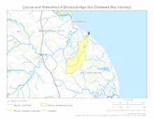
Course and Watershed of Brockonbridge Gut
External links
References
- "GNIS Detail - Brockonbridge Gut". geonames.usgs.gov. US Geological Survey. Retrieved 17 March 2020.
- "Brockonbridge Gut Topo Map, Kent County DE (Frederica Area)". TopoZone. Locality, LLC. Retrieved 17 March 2020.
- "ArcGIS Web Application". epa.maps.arcgis.com. US EPA. Retrieved 17 March 2020.
- "Brockonbridge Gut Watershed Report". Waters Geoviewer. US EPA. Retrieved 17 March 2020.
Dover (capital) | ||
| Topics |
|  |
| Society |
| |
| Cities | ||
| Towns |
| |
| Counties | ||
This article is issued from Wikipedia. The text is licensed under Creative Commons - Attribution - Sharealike. Additional terms may apply for the media files.