Croxby
Croxby is a hamlet and former civil parish in the West Lindsey district of Lincolnshire, England. It is situated approximately 5 miles (8.0 km) east from the town of Caistor.
| Croxby | |
|---|---|
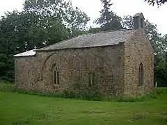 Church of All Saints, Croxby | |
 Croxby Location within Lincolnshire | |
| OS grid reference | TF189982 |
| • London | 135 mi (217 km) S |
| Civil parish | |
| District | |
| Shire county | |
| Region | |
| Country | England |
| Sovereign state | United Kingdom |
| Post town | Market Rasen |
| Postcode district | LN7 |
| Police | Lincolnshire |
| Fire | Lincolnshire |
| Ambulance | East Midlands |
| UK Parliament | |
Croxby deserted medieval village (DMV) lies to the north-east from the church, with Croxby Hall at the bottom, and along the sides of, a narrow stream running through a chalk valley.[1] At the time of the Domesday survey Croxby had a population of 36.[2]
The parish of Croxby was abolished in 1936 when it became part of the parish of Thoresway.[3]
Croxby church is dedicated to All Saints and is a Grade II* listed building of ironstone dating from the 12th century, with later additions and restorations. The font is also 12th-century.[4]
Croxby Hall is a Grade II* listed building of red brick dating from 1730.[5]
References
- Historic England. "Croxby (351782)". Research records (formerly PastScape). Retrieved 9 July 2013.
- "DMV remains, Croxby". Lincs to the Past. Lincolnshire Archives. Retrieved 26 June 2011.
- "Croxby AP/CP". A Vision of Britain through Time. University of Portsmouth. Archived from the original on 24 December 2012. Retrieved 26 June 2011.
- "Church of All Saints, Thoresway". British Listed Buildings. Retrieved 26 June 2011.
- "Croxby Hall, Thoresway". British Listed Buildings. Retrieved 26 June 2011.
External links
England Portal | |
| Unitary authorities | |
| Boroughs or districts | |
| Major settlements |
|
| Topics | |