Dduallt
Dduallt (English: Black hill) (pronounced [ðɨ.æɬt]) is a mountain in central Snowdonia, north Wales. It is the sister peak of Rhobell Fawr.
| Dduallt | |
|---|---|
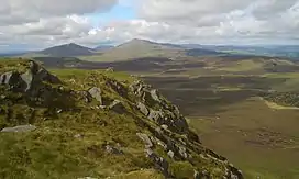 Arenig Fawr and Moel Llyfnant from Dduallt summit | |
| Highest point | |
| Elevation | 662 m (2,172 ft) |
| Prominence | 138 m (453 ft) |
| Listing | Hewitt, Nuttall, HuMP |
| Naming | |
| English translation | Black hill |
| Language of name | Welsh |
| Pronunciation | Welsh: [ˈðɨæɬt] |
| Geography | |
| Location | Gwynedd, Wales |
| Parent range | Snowdonia |
| OS grid | SH810273 |
It lies north of the A494 between Dolgellau and Llanuwchllyn. Its eastern slopes are the source of the Afon Dyfrdwy (River Dee).[1]
References
- Nuttall, John & Anne (1999). The Mountains of England & Wales - Volume 1: Wales (2nd edition ed.). Milnthorpe, Cumbria: Cicerone. ISBN 1-85284-304-7.
External links
- Dduallt is at coordinates 52.830198°N 3.765779°W
- www.geograph.co.uk : photos of Dduallt and surrounding area
This article is issued from Wikipedia. The text is licensed under Creative Commons - Attribution - Sharealike. Additional terms may apply for the media files.