Lenne
The Lenne is a tributary of the river Ruhr in the Sauerland hills, western Germany. It has caused flooding in recent years.[2]
| Lenne | |
|---|---|
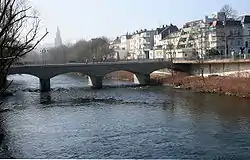 The Lenne in Iserlohn-Letmathe. | |
| Location | |
| Country | Germany |
| Physical characteristics | |
| Source | |
| • location | Sauerland |
| • elevation | 819 m (2,687 ft) |
| Mouth | |
• location | Ruhr |
• coordinates | 51°24′54″N 7°29′31″E |
| Length | 129.0 km (80.2 mi) [1] |
| Basin size | 1,355 km2 (523 sq mi) [1] |
| Discharge | |
| • average | 25 m3/s (880 cu ft/s) |
| Basin features | |
| Progression | Ruhr→ Rhine→ North Sea |
| Tributaries | |
| • left | Else (Lenne), Bigge (river), Elspe (Lenne), Grafschaft (Lenne), Uentrop (Lenne) |
| • right | Nesselbach (Lenne), Nette (Lenne), Sorpe (Lenne) |
Having its source on top of the Kahler Asten near Winterberg in an intermittent spring at an elevation of 2,687 ft (819 m), the Lenne ends after a course of 129 km flowing into the Ruhr river near the city of Hagen. With an average discharge of 25 m³/s near its mouth, it is the main tributary of the Ruhr.
References

River Lenne between Werdohl and Altena
- Hydrographic Directory of the NRW State Office for Nature, the Environment and Consumer Protection (Gewässerverzeichnis des Landesamtes für Natur, Umwelt und Verbraucherschutz NRW 2010) (xls; 4.67 MB)
- Gôppert, H.; Ihringer, J.; Plate, E. J.; Morgenschweis, G. (April 1998). "Flood forecast model for improved reservoir management in the Lenne River catchment, Germany". Hydrological Sciences—Journal—des Sciences Hydrologiques. Pub. 43 (2): 215. CiteSeerX 10.1.1.408.1817. doi:10.1080/02626669809492119.
 Media related to Lenne at Wikimedia Commons
This article is issued from Wikipedia. The text is licensed under Creative Commons - Attribution - Sharealike. Additional terms may apply for the media files.