Japan National Route 238
National Route 238 (国道238号, Kokudō Nihyaku sanjūhachi-gō) is the northernmost of the national highways of Japan. It connects the cities of Abashiri and Wakkanai in the northern part of the island and prefecture of Hokkaido in northern Japan.
 | ||||
|---|---|---|---|---|
| 国道238号 | ||||
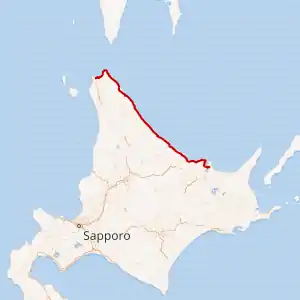 Japan National Route 238 highlighted in red | ||||
 | ||||
| Route information | ||||
| Length | 319.6 km[1] (198.6 mi) | |||
| Major junctions | ||||
| East end | ||||
| West end | ||||
| Location | ||||
| Country | Japan | |||
| Highway system | ||||
| ||||
History
On 18 May 1953 the highway was established as Second Class National Highway 238 by the Cabinet of Japan.[2] It was re-designated as General National Route 238 on 1 April 1965.[3] A curve of the road was made less sharp in Monbetsu on 1 April 2018, this shortened the total length of the highway by 30 meters (98 ft).[4]
Major junctions
The route lies entirely within Hokkaido.
| Location | km | mi | Destinations | Notes | |||
|---|---|---|---|---|---|---|---|
| Abashiri | 0.0 | 0.0 | Eastern terminus; eastern end of National Route 239 and 242 concurrency; highway continues east as National Route 39 | ||||
| 1.4 | 0.87 | Hokkaido Route 1010 north – Notoro Fishing Port | |||||
| 5.5 | 3.4 | Hokkaido Route 104 south – Kitami | |||||
| 7.2 | 4.5 | Hokkaido Route 76 east – Cape Notori | |||||
| 11.0 | 6.8 | Hokkaido Route 591 south – Kitami, Bihoro | |||||
| Kitami | 26.0 | 16.2 | Hokkaido Route 409 (Tokoro Harbor Road) west | ||||
| 27.0 | 16.8 | Hokkaido Route 1033 west – Central Tokoro | |||||
| 29.4 | 18.3 | Hokkaido Route 7 – Central Tokoro, Kitami | |||||
| 30.9 | 19.2 | Hokkaido Route 1033 east – Central Tokoro | |||||
| 31.6 | 19.6 | Hokkaido Route 442 west – Lake Saroma | |||||
| 39.4 | 24.5 | Hokkaido Route 442 east – Lake Saroma, Sakaeura | |||||
| Saroma | 41.6 | 25.8 | Hokkaido Route 103 west – Rubeshibe, Saroma | ||||
| 42.2 | 26.2 | Hokkaido Route 858 west – Kimuaneppu Cape | |||||
| 54.0 | 33.6 | Hokkaido Route 961 south – Saroma | |||||
| Yūbetsu | 60.4 | 37.5 | |||||
| 68.0 | 42.3 | Hokkaido Route 244 south – Engaru | |||||
| 77.3 | 48.0 | Hokkaido Route 712 west – Ryokuin | Western end of National Route 242 concurrency | ||||
| 79.0 | 49.1 | Hokkaido Route 204 north – Yūbetsu | |||||
| Monbetsu | 85.6 | 53.2 | Hokkaido Route 873 west – Motomonbetsu | ||||
| 89.3 | 55.5 | ||||||
| 92.3 | 57.4 | Hokkaido Route 873 east – Maruseppu | |||||
| 92.9 | 57.7 | Hokkaido Route 305 – Central Motomonbetsu, Central Monbetsu | |||||
| 93.3 | 58.0 | Hokkaido Route 304 north – Central Monbetsu, Okhotsk Sea Ice Museum of Hokkaido | |||||
| 94.9 | 59.0 | Hokkaido Route 713 – Central Monbetsu, Takinoue | |||||
| 102.1 | 63.4 | Hokkaido Route 305 east – Central Monbetsu | Northern terminus of National Route 273 | ||||
| Okoppe | 111.3 | 69.2 | Hokkaido Route 492 north – Central Okoppe | ||||
| 118.0 | 73.3 | Hokkaido Route 334 south – Nakamokoppe | |||||
| 121.2 | 75.3 | Western end of National Route 239 concurrency | |||||
| Ōmu | 129.7 | 80.6 | Hokkaido Route 883 south – Nishiokoppe | ||||
| 138.6 | 86.1 | Hokkaido Route 49 west – Bifuka | |||||
| 162.0 | 100.7 | Hokkaido Route 60 south – Shimokawa, Bifuka | |||||
| Esashi | 170.0 | 105.6 | Hokkaido Route 880 west – Kamiotoshibe | ||||
| 180.8 | 112.3 | Hokkaido Route 1023 west – Utanobori | |||||
| 199.7 | 124.1 | Hokkaido Route 12 west – Utanobori | |||||
| 200.1 | 124.3 | Hokkaido Route 1069 north – Central Esashi | |||||
| 204.2 | 126.9 | Hokkaido Route 1069 south – Central Esashi | |||||
| Hamatonbetsu | 225.5 | 140.1 | Hokkaido Route 586 west – Nakatonbetsu | ||||
| 230.1 | 143.0 | Hokkaido Route 1074 north – Tonbetsu | |||||
| 232.0 | 144.2 | Northern terminus of National Route 239 | |||||
| Sarufutsu | 241.3 | 149.9 | Hokkaido Route 710 south – Nitachinai | ||||
| 247.4 | 153.7 | Hokkaido Route 732 south – Toyotomi | |||||
| 254.4 | 158.1 | Hokkaido Route 584 west – Central Sarufutsu | |||||
| 264.0 | 164.0 | ||||||
| Wakkanai | 275.6 | 171.2 | |||||
| 298.1 | 185.2 | Hokkaido Route 889 south – Sōya Hill | |||||
| 307.6 | 191.1 | Hokkaido Route 1077 east – Onishibetsu, Numakawa | |||||
| 313.4 | 194.7 | ||||||
| 315.2 | 195.9 | Hokkaido Route 1133 south – Hokkaido Sōya Fureai Park | |||||
| 319.6 | 198.6 | Western terminus | |||||
1.000 mi = 1.609 km; 1.000 km = 0.621 mi
| |||||||
See also
 Japan portal
 Roads portal
References
- "一般国道の路線別、都道府県別道路現況" [Road statistics by General National Highway route and prefecture] (PDF) (in Japanese). Ministry of Land, Infrastructure, Transport and Tourism. Retrieved 18 February 2020.
- "二級国道の路線を指定する政令 (昭和二十八年)". Wikisource (in Japanese). Retrieved 31 January 2020.
- "二級国道の路線を指定する政令 (1962年)". Wikisource (in Japanese). Retrieved 31 January 2020.
- "国道238号の現道区間を移管" (PDF) (in Japanese). Retrieved 31 January 2020.
External links
 Media related to Category:Route 238 (Japan) at Wikimedia Commons
This article is issued from Wikipedia. The text is licensed under Creative Commons - Attribution - Sharealike. Additional terms may apply for the media files.