Florida State Road 742
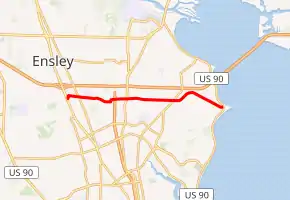
State Road 742 (SR 742) is a six-mile-long (9.7 km)east–west state highway serving Pensacola, Florida. It is both a commuter road and a bypass route that also provides access (via Ninth Avenue/SR 289 and Airport Boulevard/SR 750) for motorists to Pensacola International Airport. Locally known as Burgess Road and Creighton Boulevard, SR 742 stays within a mile south of Interstate 10 (I-10 or SR 8) from the state road's western terminus at U.S. Route 29 (US 29 or SR 95) near Ensley to SR 742's eastern terminus at US 90 in Pensacola.
 | ||||
|---|---|---|---|---|
| Burgess Road Creighton Boulevard | ||||
 | ||||
| Route information | ||||
| Maintained by FDOT | ||||
| Length | 6.886 mi[1] (11.082 km) | |||
| Major junctions | ||||
| West end | ||||
| East end | ||||
| Location | ||||
| Country | United States | |||
| State | Florida | |||
| Highway system | ||||
| ||||
SR 742 east of SR 289 was itself part of SR 289 until the mid-1970s.[2][3]
Major intersections

A sign denoting Florida State Road 742, located in Pensacola.
The entire route is in Escambia County.
| Location | mi[1] | km | Destinations | Notes | |
|---|---|---|---|---|---|
| Brent | 0.000 | 0.000 | |||
| 0.576 | 0.927 | ||||
| Ferry Pass | 2.661 | 4.282 | |||
| Pensacola | 4.599 | 7.401 | |||
| 6.886 | 11.082 | ||||
| 1.000 mi = 1.609 km; 1.000 km = 0.621 mi | |||||
References
External links
 Media related to Florida State Road 742 at Wikimedia Commons
- AARoads Highway Guide page for Florida State Road 742.
This article is issued from Wikipedia. The text is licensed under Creative Commons - Attribution - Sharealike. Additional terms may apply for the media files.