Ľubochňa
Ľubochňa (Hungarian: Fenyőháza) is a village and municipality in Ružomberok District in the Žilina Region of northern Slovakia.
Ľubochňa | |
|---|---|
Village | |
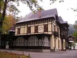 Kollár's house, spa house | |
 Coat of arms | |
 Ľubochňa Location of Ľubochňa in Slovakia | |
| Coordinates: 49°07′19″N 19°10′12″E | |
| Country | Slovakia |
| Region | Žilina |
| District | Ružomberok |
| First mentioned | 1625 |
| Area | |
| • Total | 113.67[1] km2 (43.89[1] sq mi) |
| Elevation | 451[2] m (1,480[2] ft) |
| Population (2021) | |
| • Total | 1,055[3] |
| Time zone | CET (UTC+1) |
| • Summer (DST) | CEST (UTC+2) |
| Postal code | 034 91[2] |
| Area code(s) | +421 44[2] |
| Car plate | RK |
| Website | lubochna.sk |
History
In historical records the village was first mentioned in 1818.
Geography
The municipality lies at an altitude of 451 metres and covers an area of 113.679 km². It has a population of about 1042 people.
Rerefences
- "Hustota obyvateľstva - obce [om7014rr_ukaz: Rozloha (Štvorcový meter)]". www.statistics.sk (in Slovak). Statistical Office of the Slovak Republic. 2022-03-31. Retrieved 2022-03-31.
- "Základná charakteristika". www.statistics.sk (in Slovak). Statistical Office of the Slovak Republic. 2015-04-17. Retrieved 2022-03-31.
- "Počet obyvateľov podľa pohlavia - obce (ročne)". www.statistics.sk (in Slovak). Statistical Office of the Slovak Republic. 2022-03-31. Retrieved 2022-03-31.
This article is issued from Wikipedia. The text is licensed under Creative Commons - Attribution - Sharealike. Additional terms may apply for the media files.