Bentveld
Bentveld is a village in the Dutch province of North Holland. It is a part of the municipality of Zandvoort, and lies about 5 kilometres (3 mi) west of Haarlem. Part of the village is located in the municipality of Bloemendaal, however it can be considered annexed since 1978.[3]
Bentveld | |
|---|---|
Village | |
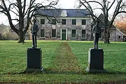 Estate Groot Bentveld | |
 Bentveld Location in the Netherlands  Bentveld Location in the province of North Holland in the Netherlands | |
| Coordinates: 52°21′57″N 4°34′18″E | |
| Country | Netherlands |
| Province | North Holland |
| Municipality | Zandvoort Bloemendaal |
| Area | |
| • Total | 0.78 km2 (0.30 sq mi) |
| Elevation | 8 m (26 ft) |
| Population (2021)[1] | |
| • Total | 1,025 |
| • Density | 1,300/km2 (3,400/sq mi) |
| Time zone | UTC+1 (CET) |
| • Summer (DST) | UTC+2 (CEST) |
| Postal code | 2116[1] |
| Dialing code | 023 |
The village was first mentioned in 1615 as Bent Velt, and means "field of moor grass (Molinia).[4] Bentveld started to developed after the tram line Zandvoort to Haarlem was constructed in 1899. The tram operated until 1957.[3]
References
- "Kerncijfers wijken en buurten 2021". Central Bureau of Statistics. Retrieved 28 April 2022.
Zandvoort only
- "Postcodetool for 2116AB". Actueel Hoogtebestand Nederland (in Dutch). Het Waterschapshuis. Retrieved 28 April 2022.
- "Bentveld". Plaatsengids (in Dutch). Retrieved 28 April 2022.
- "Bentveld - (geografische naam)". Etymologiebank (in Dutch). Retrieved 28 April 2022.
918-948 reference is unlikely to refer to this village
| Wikimedia Commons has media related to Bentveld. |
This article is issued from Wikipedia. The text is licensed under Creative Commons - Attribution - Sharealike. Additional terms may apply for the media files.