Chassignieu
Chassignieu (French pronunciation: [ʃasiɲø]) is a commune in the Isère department in southeastern France.
Chassignieu | |
|---|---|
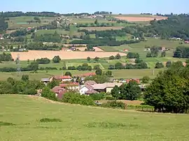 A general view of Chassignieu | |
Location of Chassignieu  | |
 Chassignieu  Chassignieu | |
| Coordinates: 45°30′04″N 5°30′19″E | |
| Country | France |
| Region | Auvergne-Rhône-Alpes |
| Department | Isère |
| Arrondissement | La Tour-du-Pin |
| Canton | Le Grand-Lemps |
| Government | |
| • Mayor (2020–2026) | Jean-Marc Bouvet |
| Area 1 | 5.17 km2 (2.00 sq mi) |
| Population | 225 |
| • Density | 44/km2 (110/sq mi) |
| Time zone | UTC+01:00 (CET) |
| • Summer (DST) | UTC+02:00 (CEST) |
| INSEE/Postal code | 38089 /38730 |
| Elevation | 373–607 m (1,224–1,991 ft) |
| 1 French Land Register data, which excludes lakes, ponds, glaciers > 1 km2 (0.386 sq mi or 247 acres) and river estuaries. | |
Geography
The Bourbre forms the commune's northwestern border. There is an old and abandoned castle next to the village, the Château de Bellegarde.
Population
| Year | Pop. | ±% |
|---|---|---|
| 1800 | 424 | — |
| 1821 | 444 | +4.7% |
| 1831 | 565 | +27.3% |
| 1841 | 606 | +7.3% |
| 1861 | 539 | −11.1% |
| 1861 | 456 | −15.4% |
| 1872 | 450 | −1.3% |
| 1881 | 428 | −4.9% |
| 1891 | 426 | −0.5% |
| 1901 | 332 | −22.1% |
| 1911 | 335 | +0.9% |
| 1921 | 287 | −14.3% |
| 1931 | 249 | −13.2% |
| 1946 | 228 | −8.4% |
| 1954 | 214 | −6.1% |
| 1962 | 252 | +17.8% |
| 1968 | 239 | −5.2% |
| 1975 | 198 | −17.2% |
| 1982 | 190 | −4.0% |
| 1990 | 188 | −1.1% |
| 1999 | 192 | +2.1% |
| 2011 | 207 | +7.8% |
See also
References
- "Populations légales 2019". The National Institute of Statistics and Economic Studies. 29 December 2021.
| Wikimedia Commons has media related to Chassignieu. |
This article is issued from Wikipedia. The text is licensed under Creative Commons - Attribution - Sharealike. Additional terms may apply for the media files.