Dolní Němčí
Dolní Němčí (until 1925 Dolněmčí) is a municipality and village in Uherské Hradiště District in the Zlín Region of the Czech Republic. It has about 3,000 inhabitants.
Dolní Němčí | |
|---|---|
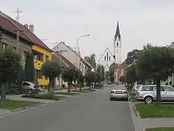 Church of Saints Philip and James | |
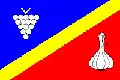 Flag  Coat of arms | |
 Dolní Němčí Location in the Czech Republic | |
| Coordinates: 48°58′6″N 17°35′9″E | |
| Country | |
| Region | Zlín |
| District | Uherské Hradiště |
| First mentioned | 1358 |
| Government | |
| • Mayor | František Hajdůch |
| Area | |
| • Total | 9.88 km2 (3.81 sq mi) |
| Elevation | 256 m (840 ft) |
| Population (2021-01-01)[1] | |
| • Total | 2,958 |
| • Density | 300/km2 (780/sq mi) |
| Time zone | UTC+1 (CET) |
| • Summer (DST) | UTC+2 (CEST) |
| Postal code | 687 62 |
| Website | www |
Dolní Němčí lies approximately 15 kilometres (9 mi) south-east of Uherské Hradiště, 30 km (19 mi) south of Zlín, and 290 km (180 mi) south-east of Prague.
History
The first written mention of Němčí is from 1261. The villages of Dolní Němčí and Horní Němčí were first distinguished in 1437.[2]
Culture
Dolní Němčí lies in the cultural region of Moravian Slovakia. The municipality is known fo the foklor group NK Dolněmčan, which was established in 1965.[3]
References
- "Population of Municipalities – 1 January 2021". Czech Statistical Office. 2021-04-30.
- "Historie obce" (in Czech). Obec Dolní Němčí. Retrieved 2021-12-09.
- "Národopisný krúžek Dolněmčan" (in Czech). Obec Dolní Němčí. Retrieved 2021-12-09.
- "Hodnotiaca správa programového rozpočtu mesta Myjava k 31. 12. 2018" (PDF) (in Slovak). Myjava. p. 20 (53). Retrieved 2019-09-05.
This article is issued from Wikipedia. The text is licensed under Creative Commons - Attribution - Sharealike. Additional terms may apply for the media files.