Hilbert, Western Australia
Hilbert is a suburb of Perth, Western Australia, located within the City of Armadale. This rural and semi-rural suburb is located on the city's fringe, and in the 2010s began to be subdivided for urban purposes.
| Hilbert Perth, Western Australia | |||||||||||||||
|---|---|---|---|---|---|---|---|---|---|---|---|---|---|---|---|
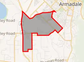 | |||||||||||||||
| Coordinates | 32.172°S 115.980°E | ||||||||||||||
| Population | 438 (2011 census)[1] | ||||||||||||||
| • Density | 50.9/km2 (131.9/sq mi) | ||||||||||||||
| Established | 2008 | ||||||||||||||
| Postcode(s) | 6112 | ||||||||||||||
| Area | 8.6 km2 (3.3 sq mi) | ||||||||||||||
| Location | |||||||||||||||
| LGA(s) | City of Armadale | ||||||||||||||
| State electorate(s) | Armadale | ||||||||||||||
| Federal division(s) | |||||||||||||||
| |||||||||||||||
The name was derived from the Hilbert family who were dairy farmers within the area. A road was proposed through Wilhelm Hermann (known as Herman or Harry) Hilbert's property in 1899, and in 1966 the unconstructed road reserve was named "Hilbert Road". There is also a large wetland in the locality generally referred to as the Hilbert Road Swamp.[2]
The locality was formed from the suburb of Brookdale on 1 April 2008, and on 4 October 2011 the suburb's western boundary was amended to coincide with the centreline of Tonkin Highway.[2]
References
- Australian Bureau of Statistics (31 October 2012). "Hilbert (State Suburb)". 2011 Census QuickStats. Retrieved 21 May 2016.
- "Armadale Road and Locality Names" (PDF). City of Armadale. Retrieved 21 May 2016.
External links
![]() Media related to Hilbert, Western Australia at Wikimedia Commons
Media related to Hilbert, Western Australia at Wikimedia Commons