Mineola, Iowa
Mineola is an unincorporated village and census-designated place in Mills County, Iowa, United States.
Mineola, Iowa | |
|---|---|
 | |
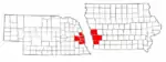
 Mineola, Iowa Location within the state of Iowa | |
| Coordinates: 41°08′35″N 95°41′44″W | |
| Country | United States |
| State | Iowa |
| County | Mills |
| Area | |
| • Total | 0.39 sq mi (1.01 km2) |
| • Land | 0.39 sq mi (1.01 km2) |
| • Water | 0.00 sq mi (0.00 km2) |
| Elevation | 1,030 ft (310 m) |
| Population (2020) | |
| • Total | 154 |
| • Density | 395.89/sq mi (153.00/km2) |
| Time zone | UTC-6 (Central (CST)) |
| • Summer (DST) | UTC-5 (CDT) |
| ZIP codes | 51554 |
| FIPS code | 19-52635 |
| GNIS feature ID | 459123 |
As of the 2010 Census, the population of Mineola was 166.[2]
Mineola is in the Glenwood Community School District.[3]
References
- "2020 U.S. Gazetteer Files". United States Census Bureau. Retrieved March 16, 2022.
- https://www.census.gov/2010census/popmap/ipmtext.php?fl=1952635
- "Home". Glenwood Community School District. Retrieved 2021-04-25.
Glenwood Community School District serves the communities of Glenwood, Mineola,[...]
- "Census of Population and Housing". Census.gov. Retrieved June 4, 2016.
External links
Metropolitan area of Omaha–Council Bluffs | ||||||
|---|---|---|---|---|---|---|
| Primary cities |
|  | ||||
| Cities over 10,000 (per 2010 Census) |
| |||||
| Cities of 5,000 to 10,000 (per 2010 Census) |
| |||||
| Cities of 1,000 to 5,000 (per 2010 Census) |
| |||||
| Census-designated places |
| |||||
| Cities and villages of fewer than 1,000 (per 2010 Census) |
| |||||
| Counties |
| |||||
Municipalities and communities of Mills County, Iowa, United States | ||
|---|---|---|
| Cities | Map of Iowa highlighting Mills County | |
| CDP | ||
| Townships | ||
| Footnotes | ‡This populated place also has portions in an adjacent county or counties | |
| ||
This article is issued from Wikipedia. The text is licensed under Creative Commons - Attribution - Sharealike. Additional terms may apply for the media files.