Saint-Pierre-de-la-Rivière-du-Sud, Quebec
Saint-Pierre-de-la-Rivière-du-Sud is a parish municipality in Quebec.
Saint-Pierre-de-la-Rivière-du-Sud | |
|---|---|
 Location within La Matapédia RCM. | |
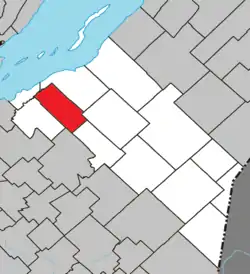
 Saint-Pierre-de-la-Rivière-du-Sud Location in province of Quebec. | |
| Coordinates: 46°55′N 70°38′W[1] | |
| Country | |
| Province | |
| Region | Chaudière-Appalaches |
| RCM | Montmagny |
| Constituted | July 1, 1855 |
| Government | |
| • Mayor | Marie Eve Proulx |
| • Federal riding | Montmagny—L'Islet— Kamouraska—Rivière- du-Loup |
| • Prov. riding | Côte-du-Sud |
| Area | |
| • Total | 91.60 km2 (35.37 sq mi) |
| • Land | 91.05 km2 (35.15 sq mi) |
| Population | |
| • Total | 840 |
| • Density | 9.2/km2 (24/sq mi) |
| • Pop 2016-2021 | |
| • Dwellings | 430 |
| Postal code(s) | |
| Area code(s) | 418 and 581 |
| Highways | |
| Website | www.stpierre rivieresud.net |
References
- Reference number 57518 of the Commission de toponymie du Québec (in French)
- Geographic code 18055 in the official Répertoire des municipalités (in French)
- https://www12.statcan.gc.ca/census-recensement/2021/dp-pd/prof/details/page.cfm?Lang=E&SearchText=Saint-Pierre&GENDERlist=1&STATISTIClist=1&DGUIDlist=2021A00052418055
Adjacent Municipal Subdivisions | ||||||||||||||||
|---|---|---|---|---|---|---|---|---|---|---|---|---|---|---|---|---|
| ||||||||||||||||
| Cities & Towns | |
|---|---|
| Municipalities | |
| Parishes | |
| |
This article is issued from Wikipedia. The text is licensed under Creative Commons - Attribution - Sharealike. Additional terms may apply for the media files.