Uriménil
Uriménil (French pronunciation: [yʁimenil] (![]() listen)) is a commune in the Vosges department in Grand Est in northeastern France.
listen)) is a commune in the Vosges department in Grand Est in northeastern France.
Uriménil | |
|---|---|
 The town hall in Uriménil | |
Location of Uriménil 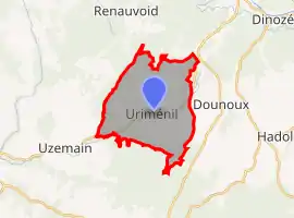 | |
 Uriménil  Uriménil | |
| Coordinates: 48°06′07″N 6°24′08″E | |
| Country | France |
| Region | Grand Est |
| Department | Vosges |
| Arrondissement | Épinal |
| Canton | Le Val-d'Ajol |
| Intercommunality | CA Épinal |
| Government | |
| • Mayor (2020–2026) | Éric Garion[1] |
| Area 1 | 15.62 km2 (6.03 sq mi) |
| Population | 1,340 |
| • Density | 86/km2 (220/sq mi) |
| Time zone | UTC+01:00 (CET) |
| • Summer (DST) | UTC+02:00 (CEST) |
| INSEE/Postal code | 88481 /88220 |
| Elevation | 338–465 m (1,109–1,526 ft) (avg. 350 m or 1,150 ft) |
| 1 French Land Register data, which excludes lakes, ponds, glaciers > 1 km2 (0.386 sq mi or 247 acres) and river estuaries. | |
Geography
The Côney flows southwest through the middle of the commune, crosses the village, and forms part of the commune's southwestern border.
See also
References
- "Répertoire national des élus: les maires". data.gouv.fr, Plateforme ouverte des données publiques françaises (in French). 2 December 2020.
- "Populations légales 2019". The National Institute of Statistics and Economic Studies. 29 December 2021.
| Wikimedia Commons has media related to Uriménil. |
This article is issued from Wikipedia. The text is licensed under Creative Commons - Attribution - Sharealike. Additional terms may apply for the media files.