Antras, Gers
Antras (Antràs in Occitan) is a commune in the Gers department in southwestern France.
Antras | |
|---|---|
Location of Antras  | |
 Antras  Antras | |
| Coordinates: 43°43′49″N 0°26′55″E | |
| Country | France |
| Region | Occitania |
| Department | Gers |
| Arrondissement | Auch |
| Canton | Gascogne-Auscitaine |
| Government | |
| • Mayor (2020–2026) | Olivier Souard[1] |
| Area 1 | 6.59 km2 (2.54 sq mi) |
| Population | 46 |
| • Density | 7.0/km2 (18/sq mi) |
| Time zone | UTC+01:00 (CET) |
| • Summer (DST) | UTC+02:00 (CEST) |
| INSEE/Postal code | 32003 /32360 |
| Elevation | 125–251 m (410–823 ft) (avg. 218 m or 715 ft) |
| 1 French Land Register data, which excludes lakes, ponds, glaciers > 1 km2 (0.386 sq mi or 247 acres) and river estuaries. | |
Geography
Antras is located in the canton of Gascogne-Auscitaine and in the arrondissement of Auch.
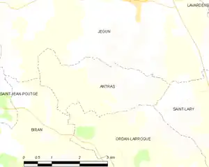
Map of Antras and its surrounding communes
Population
| Year | Pop. | ±% |
|---|---|---|
| 1790 | 150 | — |
| 1820 | 230 | +53.3% |
| 1909 | 130 | −43.5% |
| 1962 | 93 | −28.5% |
| 1968 | 86 | −7.5% |
| 1975 | 49 | −43.0% |
| 1982 | 55 | +12.2% |
| 1990 | 51 | −7.3% |
| 1999 | 58 | +13.7% |
| 2008 | 61 | +5.2% |
See also
References
- "Répertoire national des élus: les maires". data.gouv.fr, Plateforme ouverte des données publiques françaises (in French). 9 August 2021.
- "Populations légales 2019". The National Institute of Statistics and Economic Studies. 29 December 2021.
| Wikimedia Commons has media related to Antras (Gers). |
This article is issued from Wikipedia. The text is licensed under Creative Commons - Attribution - Sharealike. Additional terms may apply for the media files.