Le Houga
Le Houga (French pronunciation: [lə uɡa]; Occitan: Lo Haugar) is a commune in the Gers department in southwestern France.
Le Houga | |
|---|---|
 The church in Le Houga | |
.svg.png.webp) Coat of arms | |
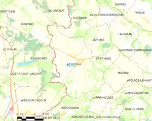
Location of Le Houga 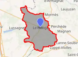 | |
 Le Houga  Le Houga | |
| Coordinates: 43°46′34″N 0°10′46″W | |
| Country | France |
| Region | Occitania |
| Department | Gers |
| Arrondissement | Condom |
| Canton | Grand-Bas-Armagnac |
| Intercommunality | Bas-Armagnac |
| Government | |
| • Mayor (2020–2026) | Patricia Galabert |
| Area 1 | 31.51 km2 (12.17 sq mi) |
| Population | 1,161 |
| • Density | 37/km2 (95/sq mi) |
| Time zone | UTC+01:00 (CET) |
| • Summer (DST) | UTC+02:00 (CEST) |
| INSEE/Postal code | 32155 /32460 |
| Elevation | 87–153 m (285–502 ft) (avg. 148 m or 486 ft) |
| 1 French Land Register data, which excludes lakes, ponds, glaciers > 1 km2 (0.386 sq mi or 247 acres) and river estuaries. | |
Geography
Le Houga and its surrounding communes
Population
| Year | Pop. | ±% |
|---|---|---|
| 1962 | 1,164 | — |
| 1968 | 1,182 | +1.5% |
| 1975 | 1,124 | −4.9% |
| 1982 | 1,173 | +4.4% |
| 1990 | 1,166 | −0.6% |
| 1999 | 1,101 | −5.6% |
| 2008 | 1,141 | +3.6% |
References
- "Populations légales 2019". The National Institute of Statistics and Economic Studies. 29 December 2021.
| Wikimedia Commons has media related to Le Houga. |
This article is issued from Wikipedia. The text is licensed under Creative Commons - Attribution - Sharealike. Additional terms may apply for the media files.