Moombooldool, New South Wales
Moombooldool is a village community in the central north part of the Riverina, located on the Burley Griffin Way (B94). It is situated by road, about 9 kilometres east of Barellan and 12 kilometres west of Kamarah. The village is also equally 420 kilometres distant from both Sydney and Melbourne as the crow flies.
| Moombooldool New South Wales | |
|---|---|
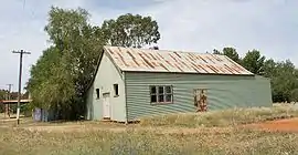 Public hall at Moombooldool | |
Moombooldool | |
| Coordinates | 34°18′6″S 146°40′41″E |
| Population | 30 (2016 Census) |
| Postcode(s) | 2665 |
| Elevation | 158 m (518 ft) |
| Location |
|
| LGA(s) | Narrandera Shire |
| Region | Riverina |
| County | Cooper |
| State electorate(s) | Cootamundra |
| Federal division(s) | Riverina |
Moombooldool Post Office opened on 15 April 1912 and closed in 1982.[1] The railway line opened in 1908. The station closed in 1975 however the line remains open for goods trains.[2]
Notes and references
- Phoenix Auctions History, Post Office List, retrieved 19 January 2021
- Moombooldool Station. NSWrail.net, accessed 10 November 2010.
External links
| Wikimedia Commons has media related to Moombooldool, New South Wales. |
{
| Preceding station | Former Services | Following station | ||
|---|---|---|---|---|
| Barellan towards Roto |
Temora- Roto Line | Kamarah towards Temora | ||
This article is issued from Wikipedia. The text is licensed under Creative Commons - Attribution - Sharealike. Additional terms may apply for the media files.