Hecmanville
Hecmanville (French pronunciation: [ɛkmɑ̃vil]) is a commune in the Eure department in northern France.
Hecmanville | |
|---|---|
 Old town hall and war memorial | |
Location of Hecmanville 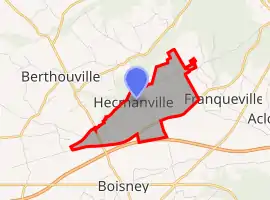 | |
 Hecmanville  Hecmanville | |
| Coordinates: 49°10′29″N 0°39′39″E | |
| Country | France |
| Region | Normandy |
| Department | Eure |
| Arrondissement | Bernay |
| Canton | Brionne |
| Government | |
| • Mayor (2020–2026) | Jean Duthilleul[1] |
| Area 1 | 2.99 km2 (1.15 sq mi) |
| Population | 187 |
| • Density | 63/km2 (160/sq mi) |
| Time zone | UTC+01:00 (CET) |
| • Summer (DST) | UTC+02:00 (CEST) |
| INSEE/Postal code | 27325 /27800 |
| Elevation | 135–161 m (443–528 ft) (avg. 165 m or 541 ft) |
| 1 French Land Register data, which excludes lakes, ponds, glaciers > 1 km2 (0.386 sq mi or 247 acres) and river estuaries. | |
Population
| Year | Pop. | ±% |
|---|---|---|
| 1962 | 49 | — |
| 1968 | 61 | +24.5% |
| 1975 | 58 | −4.9% |
| 1982 | 86 | +48.3% |
| 1990 | 70 | −18.6% |
| 1999 | 104 | +48.6% |
| 2008 | 117 | +12.5% |
See also
References
- "Répertoire national des élus: les maires". data.gouv.fr, Plateforme ouverte des données publiques françaises (in French). 9 August 2021.
- "Populations légales 2019". The National Institute of Statistics and Economic Studies. 29 December 2021.
| Wikimedia Commons has media related to Hecmanville. |
This article is issued from Wikipedia. The text is licensed under Creative Commons - Attribution - Sharealike. Additional terms may apply for the media files.