Bergnicourt
Bergnicourt is a commune in the Ardennes department in northern France.
Bergnicourt | |
|---|---|
 The town hall in Bergnicourt | |
 Coat of arms | |
Location of Bergnicourt 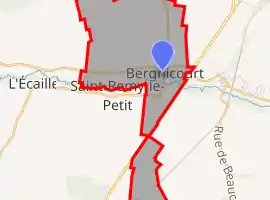 | |
 Bergnicourt  Bergnicourt | |
| Coordinates: 49°25′12″N 4°15′21″E | |
| Country | France |
| Region | Grand Est |
| Department | Ardennes |
| Arrondissement | Rethel |
| Canton | Château-Porcien |
| Government | |
| • Mayor (2020–2026) | Cyrille Marquès[1] |
| Area 1 | 8.16 km2 (3.15 sq mi) |
| Population | 293 |
| • Density | 36/km2 (93/sq mi) |
| Time zone | UTC+01:00 (CET) |
| • Summer (DST) | UTC+02:00 (CEST) |
| INSEE/Postal code | 08060 /08300 |
| Elevation | 72–136 m (236–446 ft) (avg. 84 m or 276 ft) |
| 1 French Land Register data, which excludes lakes, ponds, glaciers > 1 km2 (0.386 sq mi or 247 acres) and river estuaries. | |
Population
| Year | Pop. | ±% |
|---|---|---|
| 1962 | 120 | — |
| 1968 | 134 | +11.7% |
| 1975 | 146 | +9.0% |
| 1982 | 159 | +8.9% |
| 1990 | 164 | +3.1% |
| 1999 | 151 | −7.9% |
| 2008 | 172 | +13.9% |
See also
References
- "Répertoire national des élus: les maires". data.gouv.fr, Plateforme ouverte des données publiques françaises (in French). 2 December 2020. Retrieved 7 December 2020.
- "Populations légales 2019". The National Institute of Statistics and Economic Studies. 29 December 2021.
| Wikimedia Commons has media related to Bergnicourt. |
This article is issued from Wikipedia. The text is licensed under Creative Commons - Attribution - Sharealike. Additional terms may apply for the media files.