Hierges
Hierges (French pronunciation: [jɛʁʒ]) is a commune in the Ardennes department in the Grand Est region in northern France.
Hierges | |
|---|---|
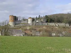 The chateau in Hierges | |
 Coat of arms | |
Location of Hierges  | |
 Hierges  Hierges | |
| Coordinates: 50°06′21″N 4°44′26″E | |
| Country | France |
| Region | Grand Est |
| Department | Ardennes |
| Arrondissement | Charleville-Mézières |
| Canton | Givet |
| Intercommunality | Ardenne Rives de Meuse |
| Government | |
| • Mayor (2020–2026) | Isabelle Bodart[1] |
| Area 1 | 4.05 km2 (1.56 sq mi) |
| Population | 170 |
| • Density | 42/km2 (110/sq mi) |
| Time zone | UTC+01:00 (CET) |
| • Summer (DST) | UTC+02:00 (CEST) |
| INSEE/Postal code | 08226 /08320 |
| 1 French Land Register data, which excludes lakes, ponds, glaciers > 1 km2 (0.386 sq mi or 247 acres) and river estuaries. | |
Hierges is located in the Meuse valley along the Belgian border.
Population
| Year | Pop. | ±% |
|---|---|---|
| 1962 | 245 | — |
| 1968 | 297 | +21.2% |
| 1975 | 324 | +9.1% |
| 1982 | 300 | −7.4% |
| 1990 | 254 | −15.3% |
| 1999 | 220 | −13.4% |
| 2008 | 212 | −3.6% |
Sights and monuments
- Château de Hierges, a castle whose origins go back to the 16th century, was built on the site of an earlier 9th century castrum.
References
- "Répertoire national des élus: les maires". data.gouv.fr, Plateforme ouverte des données publiques françaises (in French). 9 August 2021.
- "Populations légales 2019". The National Institute of Statistics and Economic Studies. 29 December 2021.
| Wikimedia Commons has media related to Hierges. |
This article is issued from Wikipedia. The text is licensed under Creative Commons - Attribution - Sharealike. Additional terms may apply for the media files.