Saint-Uze
Saint-Uze (French pronunciation: [sɛ̃.t‿yz]; Arpitan: Sent-Uson) is a commune in the Drôme department in southeastern France.
Saint-Uze | |
|---|---|
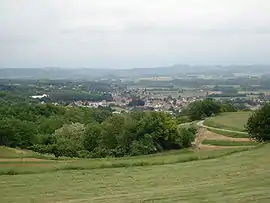 A general view of Saint-Uze | |
.svg.png.webp) Coat of arms | |
Location of Saint-Uze  | |
 Saint-Uze  Saint-Uze | |
| Coordinates: 45°10′48″N 4°51′40″E | |
| Country | France |
| Region | Auvergne-Rhône-Alpes |
| Department | Drôme |
| Arrondissement | Valence |
| Canton | Saint-Vallier |
| Government | |
| • Mayor (2020–2026) | Jérôme Caire[1] |
| Area 1 | 10.1 km2 (3.9 sq mi) |
| Population | 2,062 |
| • Density | 200/km2 (530/sq mi) |
| Time zone | UTC+01:00 (CET) |
| • Summer (DST) | UTC+02:00 (CEST) |
| INSEE/Postal code | 26332 /26240 |
| Elevation | 148–357 m (486–1,171 ft) (avg. 189 m or 620 ft) |
| 1 French Land Register data, which excludes lakes, ponds, glaciers > 1 km2 (0.386 sq mi or 247 acres) and river estuaries. | |
Geography
The Galaure forms most of the commune's southern border.
Population
| Year | Pop. | ±% |
|---|---|---|
| 1911 | 1,760 | — |
| 1962 | 1,970 | +11.9% |
| 1968 | 1,980 | +0.5% |
| 1975 | 2,086 | +5.4% |
| 1982 | 2,003 | −4.0% |
| 1990 | 1,846 | −7.8% |
| 1999 | 1,589 | −13.9% |
| 2008 | 1,884 | +18.6% |
Notables
See also
References
- "Répertoire national des élus: les maires". data.gouv.fr, Plateforme ouverte des données publiques françaises (in French). 2 December 2020.
- "Populations légales 2019". The National Institute of Statistics and Economic Studies. 29 December 2021.
| Wikimedia Commons has media related to Saint-Uze. |
This article is issued from Wikipedia. The text is licensed under Creative Commons - Attribution - Sharealike. Additional terms may apply for the media files.