Saint-Paul-la-Coste
Saint-Paul-la-Coste (French pronunciation: [sɛ̃ pɔl la kɔst]; Occitan: Sent Pau de la Còsta) is a commune in the Gard department in southern France.
Saint-Paul-la-Coste | |
|---|---|
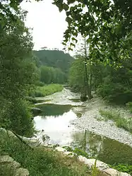 The Galeizon river | |
.svg.png.webp) Coat of arms | |
Location of Saint-Paul-la-Coste 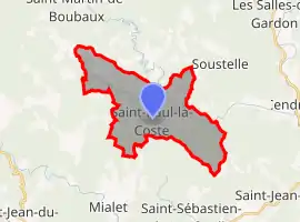 | |
 Saint-Paul-la-Coste  Saint-Paul-la-Coste | |
| Coordinates: 44°09′02″N 3°58′13″E | |
| Country | France |
| Region | Occitania |
| Department | Gard |
| Arrondissement | Alès |
| Canton | La Grand-Combe |
| Intercommunality | Alès Agglomération |
| Government | |
| • Mayor (2020–2026) | Adrien Chapon[1] |
| Area 1 | 18.95 km2 (7.32 sq mi) |
| Population | 291 |
| • Density | 15/km2 (40/sq mi) |
| Time zone | UTC+01:00 (CET) |
| • Summer (DST) | UTC+02:00 (CEST) |
| INSEE/Postal code | 30291 /30480 |
| Elevation | 168–680 m (551–2,231 ft) (avg. 650 m or 2,130 ft) |
| 1 French Land Register data, which excludes lakes, ponds, glaciers > 1 km2 (0.386 sq mi or 247 acres) and river estuaries. | |
Population
| Year | Pop. | ±% |
|---|---|---|
| 1793 | 820 | — |
| 1821 | 725 | −11.6% |
| 1846 | 828 | +14.2% |
| 1872 | 742 | −10.4% |
| 1901 | 621 | −16.3% |
| 1926 | 434 | −30.1% |
| 1946 | 310 | −28.6% |
| 1962 | 134 | −56.8% |
| 1968 | 184 | +37.3% |
| 1975 | 194 | +5.4% |
| 1982 | 172 | −11.3% |
| 1990 | 193 | +12.2% |
| 1999 | 220 | +14.0% |
| 2008 | 269 | +22.3% |
See also
References
- "Répertoire national des élus: les maires". data.gouv.fr, Plateforme ouverte des données publiques françaises (in French). 2 December 2020.
- "Populations légales 2019". The National Institute of Statistics and Economic Studies. 29 December 2021.
| Wikimedia Commons has media related to Saint-Paul-la-Coste. |
This article is issued from Wikipedia. The text is licensed under Creative Commons - Attribution - Sharealike. Additional terms may apply for the media files.